All published articles of this journal are available on ScienceDirect.
Natural and Anthropogenic Impacts on Forest Structure: A Case Study of Uttarakhand State
Abstract
Forests are among the most important natural resources in Uttarakhand as they occupy 71% of the geographic area and contribute a good share in state economy. They are rich repositories of biodiversity and are providers of ecosystem goods and services to both regional and global community. People are dependent on forests for fuel wood, grass and other biomass. But unfortunately recent trend of data shows a huge degradation of forestland due to natural and anthropogenic activities. Variations in climatic condition and natural disasters are triggering rate of degradation of forests in Uttarakhand. The present paper reviews the status of forest in Uttarakhand and discusses the major natural and anthropogenic factors responsible for its degradation.
1. INTRODUCTION
1.1. Geographical Location of Study Area
Uttarakhand is the 27th state of Republic of India which lies between 280 44' & 310 28' N Latitude and 770 35' & 810 01' E longitude. It was carved out of Uttar Pradesh on 9th November 2000 and was divided into two divisions of Garhwal and Kumaon with total of 13 districts namely Pithoragarh, Bageshwar, Champawat, Nainital, Pithoragarh, Udham Singh Nagar, Dehradun, Haridwar, Tehri Garhwal, Uttarkashi, Chamoli, Pauri Garhwal, Rudraprayag. It has a total geographical area of 53,483 km2, of which large area is mountainous with under snow cover and steep slopes. It shares an international boundary with Nepal in the East and China in the North. In the West, it touches state Himachal Pradesh, and in the South, Uttar Pradesh. The human population of the state is 101.167 lakhs (2011census) out of which approximately 70 percent lives in rural areas. There are four major river systems viz. Ganga, Yamuna, Ramganga and Sharda originating from the state along with their tributaries serving as the prime source of water for drinking, irrigation and hydropower. A brief statistics of Uttarakhand state is mentioned in Table 1.
1.2. Classification of Study Area
The major wealth of the state is its rich biodiversity forests. Based on altitude different climate zones are classified as warm temperate (900 m-1800 m), cool temperate (1800 m-2400 m), cold zones (2400 m-3000 m), alpine zone (3000 m-4000 m), glacier zone (4000 m-4800 m), and frozen zone (above 4800 m). The average annual rainfall is about 1550 mm. Based on land elevation, the State is classified as terrain region (less than 300 m above msl), lower hilly region (300-600 m), upper hilly region (600- 2400 m) high altitude region (2400-4500 m) and upper high altitude region (above 4500 m). Udham Singh Nagar and Haridwar are the only plain districts in the State. The state comprises of five lithotectonically and physiographically distinct subdivisions namely, the Outer Himalaya (comprising the Tarai and Bhabhar), Sub-Himalayan belt of the Siwalik, the Lesser Himalaya, the Greater Himalaya and the Trans-Himalaya or Tethys. Human habitation is found up to an altitude of 3500 m above msl; however, the zone between 1200 - 2000 m, largely falling in the Lesser Himalaya (1500 - 2500 m above msl), is densely populated.
| 1 | Geographical area of Uttarakhand | 53, 483 Sq.Km. |
| 2 | Total Forest area under various classes | 37999.60 Sq.Km. |
| 3 | Per Capita Forest Area | 0.376 Hectare |
| 4 | Total Forest area as percentage of geographical area | 71.05% |
| 5 | Forest area under Forest Department | 25,863.18 Sq.Km. |
| 6 | Forest Cover | 24,508 Sq.Km. |
| 7 | National Parks(No./Sq.Km) | 6/ 5,001.82 |
| 8 | Wildlife Sanctuaries (No./Sq.Km) | 7/ 2,683.79 |
| 9 | Conservation Reserves (No./Ha.) | 4/ 21244.56 |
| 10 | Total Reserve Forest | 26,547.00 Sq.Km. |
| 11 | Total (Protected Forests) | 154.02 Sq.Km. |
| 12 | Total (Civil & Soyam Forests) | 9,730.555 Sq.Km. |
| 13 | Private Forests (Municipal and Cantonment etc.) | 123.506 Sq.Km. |
1.3. Climate and Soil of Uttarakhand
In the mountainous regions of Uttarakhand the climate is cold, humid and temperate type but it varies with the altitude. The valleys are hot in summer and much colder in winter. So overall Uttarakhand has a temperate climate except in the plain areas where the climate is tropical. The state has different types of soil ranging from low to medium fertile in status. The major soil groups in the state are brown hill soil, mountain meadow soil, sub-mountain soils, and red loamy soils. Most of the soils in the high altitude region are acidic in nature. The Tarai soils are mostly rich, clayey loams, mixed with humus considered best for the cultivation of rice and sugarcane.
2. UTTARAKHAND FOREST
The state ranks sixth among the other states in terms of percentage of recorded forest area. The total forest area under various classes of the State is 37,999.53 km2, which is 71% of the geographic area. The forest area under forest department is 25,863.18 km2. According to forest survey of India (FSI-2015), very dense forest is 4,785 km2, moderately dense forest is 14,111 km2, open forest is 5,612 km2 and Scrub is 262 km2. About 19% area of the State is under permanent snow cover, glaciers and steep slopes and therefore it is unsuitable for trees growth. The forest department of Uttarakhand has 13 circles, 44 divisions, 284 ranges and 1569 beat. The human and livestock population is largely dependent on forests due to agrarian-economy leading to heavy pressure on forests and consequent degradation of ecology and environment of the area. Although the State of Uttarakhand is well endowed with biological resources, the last few decades have seen an increase in pressure on the state's forest ecosystems as for e.g. the Shiwalik range of Uttarakhand has been virtually degraded of its forest cover and forested landscape has been pushed to the upper regions. In the most populated belt (1000-2000 m asl) of Uttarakhand state, Oak (Quercus spp.) and Pine (Pinus roxburghii) forests form the dominant forest vegetation which cover about 12.3% and 16.4%, respectively of the total geographical area of the state (Singh & Singh, 1992).
3. TYPES OF FORESTS IN UTTARAKHAND
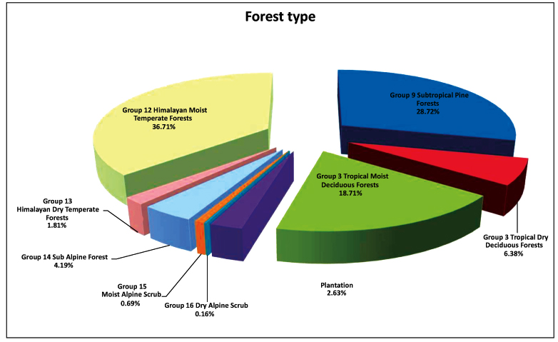
The different types of forests found in Uttarakhand (Fig. 1) as classified by Champion and Seth, 1968 are:
Moist Alpine Scrub: It occurs at tree line around an altitude of 3500 m and the dominant species noticed here are Betula utilis and Rhododendron campanulatum
Sub Alpine Forest: It exists at an altitude of 2900 m to 3500 m above sea level and are characterised by patches of Abies-Betula forest interspersed with grassland called as Bugyals.
Himalayan Dry Temperate Forest: This type of forest is found in the inner dry trans-Himalayan valleys of the state. Major species occurring here are Cedrus deodara, a highly valued endemic species, grows mainly in the western part of the range. Other species that occur between 1,900 and 2,700 m are blue pine (Pinus wallichiana), Juniperus spp.
Himalayan Moist Temperate Forest: This type of forest occurs between 1600-2900m altitudes and is mainly characterised by coniferous species such as Picea smithiana, Abies pindrow, Cedrus deodara, Betula spp. and Quercus spp.
Sub Tropical Pine Forest: This type of forest is found in the lower region of Himalayas with pines as the dominant species.
Tropical Dry Deciduous Forests: This type of forest occurs in the dry southern face of Shiwaliks and adjoining plain’s area. It is open and mixed type forest with the major species as shorea robusta, Terminalia tomentosa, Anogeissus latifolia,etc.
Littoral and Swamp Forest: This type of forest occurs in the valleys of the foothills, characterised by the presence of water loving species such as Ficus glomerata, Syzygium cumini, Pterospermum acerifolium and Diospyros embryopteris
Tropical Moist Deciduous Forests: This multi-storey type forest is found in the moist regions of the lower Himalayas and tarai area. The dominant vegetation of these forests is Terminalia tomentosa, Adina cordifolia, Anogeissus latifolia and Shorea robusta

4. FOREST BIODIVERSITY
Forests are the important natural resource of Uttarakhand which supports survival of the people in the mountains as food, fuel, fodder, and shelter. Besides harbouring hundreds of species of medicinal and food plants, the forests of Uttarakhand are also home of many endemic and endangered fauna and flora. Some of the endemic flora of Uttarakhand forest are Garuga pinnata, Madhuca longifolia, Aristolochia indica, Bacopa monnieri,Ceropegia bulbosa, Gloriosa superba, Rauvolfia serpentina etc.
Uttarakhand state is blessed with variety of vegetation ranging from tropical deciduous to alpine vegetation. In the lower region upto 800 m, moist tropical and dry deciduous forest of sal, teak or mixed forest of Acacia, Aegle, Haldina, Syzygium and Terminalia species are found. The dominant trees in the region are Acacia catechu, Albizia lebbeck, Butea monosperma, Aegle marmelos, Dalbergia sissoo, Diospyros melanoxylon, Ficus auriculata, Ficus religiosa, Syzygium cumini, Shorea robuta, Terminalia alata, Cassia fistula, Ficus benghalensis, etc. The dominant shrubs found at this altitude are Zanthoxylum armatum, Berberis lycium, Berberis asiatica, Rubus ellipticus, Grewia hirsuta, Ziziphus mauritiana, Lantana camara, etc. The most common herbs at this altitude are Argemone mexicana, Eclipta alba, Saccharum spontaneum, Cassia tora, Desmostachya bipinnata, Ocimum basilicum, Tribulus terrestris, Alternanthera sessilis, etc.
With an altitude of 1000-3000 m mixed forest of Abies pindrow, Picea smithiana, Myrica esculenta, Acer caesium, Lyonia ovalifolia, Betula alnoides, Quercus leucotrichophora and Rhododendron arboretum, Quercus semecarpifolia, Aesculus indica, Taxus wallichiana, Picea smithiana, Cedrus deodara, Pinus roxburghii,etc. The most common herbs at this altitude are Morina longifolia, Paris polyphylla, Anemone obtusiloba, Giganteum spp, etc. The dominant shrubs found at this altitude are Inula cuspidata, Mahonia nepalensis, Viburnum cotinifolium, Girardinia heterophylla, etc. (Kumar & Rawat, 2011).
The major animals of Uttarakhand forests are tiger, deer, monkey, kites, elephants, leopard, black bear, brown bear, sloth bear, musk dear, stag, sambhar, barking deer, bharal, thar, goral, crocodile, ghariyal, blue bull, serow, wild pig, vulture and cheel
5. FOREST DEGRADATION
Uttarakhand forests are subjected to different stresses like over extraction, live-stock grazing, forest fires, climate change, natural calamities, encroachment and illicit felling. According to the report submitted by FSI in 2015, the forest cover of Uttarakhand has been found to be decreased 268sqkm in last two years. Out of 13 districts, maximum forest cover lost was found in Uttarkashi (73sqkm) followed by Nainital (70sqkm), Udham Singh Nagar (40sqkm), Haridwar (27sqkm) and Bagheshwar (22sqkm). The main reasons for decrease in forest cover mentioned in the report were rotational felling and diversion of forest land for development activities. A study by Prabhakar et al. (2006) estimated that 78% of the forest (including scrub) area was degraded and had a crown cover of less than 40% in Almora district of Uttarakhand by different developmental activities. Disturbances in the forest structure increases the rate of species loss and create more opportunities for introduction of invasive species such as Eupatorium, Lantana camara, Parthenium, and Ageratum spp. in the natural forests, which will have a competitive impact on existing species. In the Pithoragarh district a net deforestation rate of -0.13 and a gross deforestation rate of 0.52% was estimated in between 1976 to 2006 (Munsi et al. 2009). Similarly in the Kuchgad micro-watershed of Almora district, a net deforestation rate of 0.48 was noticed from 1967 to 1997 (Wakeel et al. 2005). These authors suggest that with increasing human activities, the deforestation rate has increased over the studied years in Uttarakhand. Major causes for degradation of forest in Uttarakhand are discussed below.
5.1. Climate Change
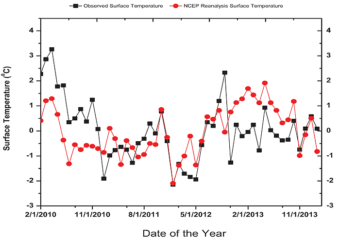
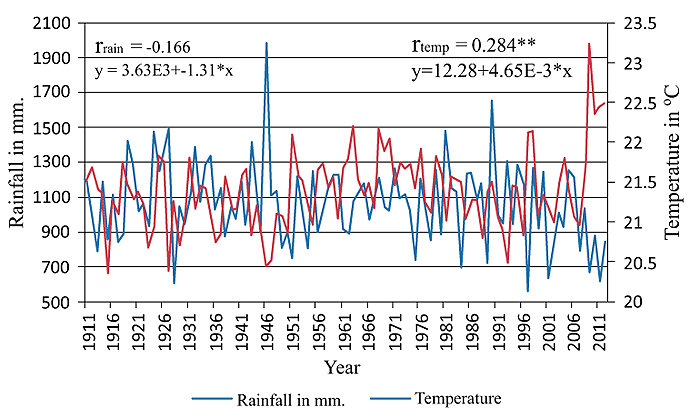
The major factor that controls the ecology of a region is climate (Faisal, 2008). Slight change in climate can significantly alter the growth, abundance, survival, composition, productivity, diversity and distribution of species in an ecosystem (Leemans & Eickhout, 2004). Forest ecosystems are one of the most vulnerable ecosystems to any change in the climate (IPCC, 2001). An indication of climate change is the abrupt fluctuation in the meteorological data. Fig. 2 shows 4-year record of monthly averaged surface temperature observations (Hourly) over the 2010-2014 period for the right bank of Alaknanda river Chauras campus, HNB Garhwal University (30°22”N 78°78” E, 560 metres) has been examined to reveal surface temperature trend in Garhwal region. Similarly, monthly averaged surface temperatures derived from the NCEP reanalysis have been examined over the same time period for the Garhwal region (30°22”N 78°78” E). Considerable variation of temperatures from year to year has been observed in both data sets. Trends in annual mean temperature anomalies showed an increase in surface temperature in this region of Garhwal region during past four years. Based on mean monthly and annual surface air temperature records at the Chauras campus, HNB Garhwal University, gradual warming of the order of 0.2 °C (± 0.022) per year has been observed as per NCEP reanalysis data. However, Annual surface temperature at Chauras campus, HNB Garhwal University has been observed 1.58 ± 1.22 °C averaged during 2010 and -0.08 ± 0.47 °C averaged during 2013. Similarly, in a study Mishra (2014) conducted analysis of 100 years of temperature and rainfall data and observed that the Uttarakhand region has recorded a declining rainfall trend during the 1911-1970 period and after 1970 onward, this trend has become steeper. Furthermore, temperature trend of the region shows an increase in warming with year which was more prominent during the last decade (Fig. 3).
Due to increase in temperatures, rapid deforestation, habitat destruction, change in vegetation, scarcity of water and corridor fragmentation may lead extinction of wild flora and fauna (Negi et al. 2012). The abrupt changes in climatic conditions of Uttarakhand are directly or indirectly affecting the vegetation growth and regeneration of important forest species. The regeneration of many species is dependent on the monsoon rainfall mainly the dominant Sal, Banj Oak and Telonj oak in the forests. The variation in rainfall and temperature may lead to changes in phenological events such as flowering, fruiting, budding, coloration etc. of many species, particularly the dominant oaks. In the Himalayan mountains early flowering of several members of Rosaceae (e.g., Pyrus, Prunus spp.) and Rhododendrons are considered the impact of global warming (Khanduri et al. 2008; Negi et al., 2012). Early bud break in Betula utilis has been recorded in 2010 as compared to earlier years (Rai et al., 2010). One of the major consequence of Global warming is the shifting of vegetation from lower elevation to higher elevation and therefore alpine ecosystems are more are very susceptible to the adverse effects of climate change. The species surviving at this region will have no space for their upward movement. (Kumar et al. 2012). Disturbed and fragmented forests and monoculture forests are considered to be more vulnerable to climate change (Rosenzweig 1995; Jandl et al. 2007).


5.2. Natural Calamities
The frequency of natural calamities in Uttarakhand has increased in last few years mostly heavy rainfall, landslide, earthquakes, cloudburst and avalanche (Table 2). These all are directly or indirectly indicating the impact of climate change. The problems of landslides, subsidence and erosion are quite common in the Uttarakhand due to the contribution of several factors like geological movements, structure, lithology, soil cover, vegetal cover; weather and climatic changes. The problem of landslide is majorly linked to the nature of earthquakes in the region. In the state the frequency of earthquakes per year has been increased in last decade. The other natural calamity i.e. heavy rainfall also shows high frequency of occurrence in 2013, 2014 and 2015. In past few years the problem of cloud burst in Uttarakhand has also caused very severe damage to living and non living thing. Overall all the natural calamities in the state have severely affected the forest ecology directly or indirectly.
| Year | Earthquakes | Landslide | Cloud Burst | Avalanche | Heavy Rainfall |
|---|---|---|---|---|---|
| 2001 | 0 | 0 | 0 | 0 | 1 |
| 2002 | 0 | 0 | 0 | 0 | 0 |
| 2003 | 0 | 1 | 1 | 0 | 1 |
| 2004 | 0 | 1 | 1 | 0 | 2 |
| 2005 | 0 | 1 | 1 | 0 | 1 |
| 2006 | 7 | 1 | 0 | 0 | 0 |
| 2007 | 5 | 1 | 1 | 0 | 1 |
| 2008 | 3 | 1 | 0 | 8 | 0 |
| 2009 | 7 | 1 | 1 | 0 | 1 |
| 2010 | 5 | 1 | 5 | 0 | 12 |
| 2011 | 9 | 1 | 3 | 1 | 2 |
| 2012 | 8 | 1 | 1 | 0 | 4 |
| 2013 | 8 | 2 | 2 | 2 | 12 |
| 2014 | 9 | 2 | 3 | 0 | 16 |
| 2015 | 8 | 2 | 4 | 0 | 19 |
5.3. Forest Fires
Forest fires in the Uttarakhand state has been a common phenomenon which is increasing more frequently in the decade due to rising temperatures. Forest fires generally occur in two phases; late March and early April when the accumulation of fresh litter can burn, and May-June, when high temperatures, low humidity, extreme dryness becomes favourable. Uttarakhand forests are made up of many species of trees; including chir pine, blue pine, ban oak, sal, sissoo, eucalyptus, etc. The most fire prone zone is the banj oak at the higher altitudes and the chir pine zone, which occupies 17% of the total forest area, and its transition zone with sal (11% of the total forest area) at the lower altitude, a zone with the maximum habitation. Controlled forest fires help in removing and dried litter and allow new growth to come up. However, uncontrolled forest fires, especially summer fires, cause severe damage to the forest biodiversity. Low precipitation during summer season reduces moisture level in the forest making it more susceptible to catch fire and spread quickly over large area of the forest land. It has been observed that forest fires occur mainly due to lightening but in case of Uttarakhand occurrences due to lightening is less as compared to anthropogenic occurrence. All fires in the chir pine forests of Uttarakhand are man-made intentional or accidental. Of the total forest fires incidences in Uttarakhand, 63% were intentional and remaining 37% were accidental (Tiwari et al., 1986, 1987). Table 3 is explaining that a large fraction of area is affected every year due to forest fires and correspondingly a good amount of economic loss is seen in Uttarakhand. Some other effects of forest fires are change in species composition, loss of micro flora and fauna, loss of seeds, loss of habitat of particular species, change in microclimate, migration of species, soil desiccation, soil erosion resulting in landslides and invasion by exotic species.
| Year | Area Affected (Ha.) | Estimated Loss (INR lakhs) |
|---|---|---|
| 1999-2000 | 925.00 | 2.99 |
| 2000-2001 | 1393.00 | 1.17 |
| 2001-2002 | 3231.00 | 5.19 |
| 2002-2003 | 4983.00 | 10.12 |
| 2003-2004 | 4850.00 | 13.14 |
| 2004-2005 | 3652.00 | 10.82 |
| 2005-2006 | 562.44 | 1.62 |
| 2006-2007 | 1595.35 | 3.67 |
| 2007-2008 | 2369.00 | 2.68 |
| 2008-2009 | 4115.00 | 4.79 |
| 2009-2010 | 1610.82 | 0.05 |
| 2010-2011 | 231.75 | 0.30 |
| 2011-2012 | 2826.30 | 3.03 |
| 2012-2013 | 2823.9 | 4.28 |
| 2013-2014 | 930.33 | 4.39 |
5.4. Encroachment on Forest Areas and Illicit Felling
Increasing population leading to poverty is the major factor for stimulating forestland encroachment. In Uttarakhand state large population is below poverty level and most of them encroach forests for shelter, food and a range of subsistence products like fuel wood, food, fodder, timber etc. Forest encroachment results in forest degradation which further results in land degradation and leads to agricultural stagnation and even a lowering of productivity, which in turn promotes further encroachment and completes the vicious cycle. As per the report given by FSI, 2015, the total forest area encroached in Uttarakhand state as on 31 March 2015 is 9646.607 Ha. In the total, Kumaun divison contribute 8318.3 Ha. and Garhwal divison 1323.2 Ha. While the contribution from protected areas includes Rajaji National Park 2.988 Ha, Corbett Tiger reserve 1.980Ha and Nanda Devi Biosphere Reserve 0.117 Ha. To control encroachment effective legal restrictions should be forced in the state.
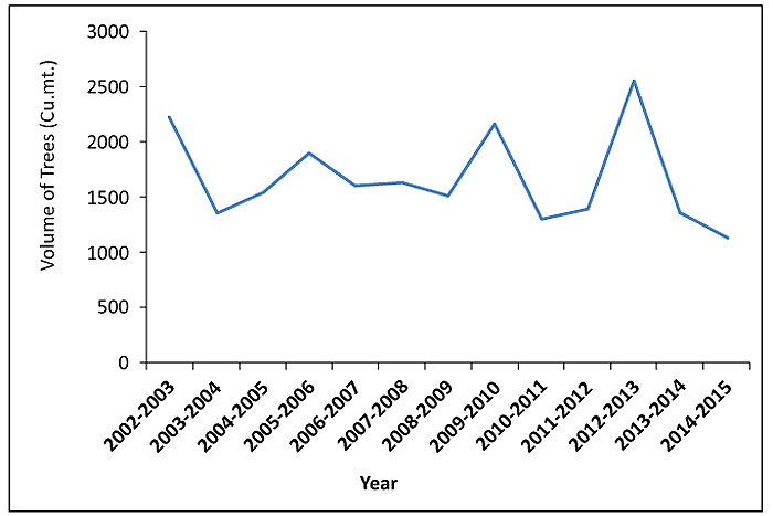
Fig. 4 shows trend of illicit felling of trees in the state since 2001. Illicit felling is one of the important causes for forest degradation in Uttarakhand. Many strategies are implemented by government against illicit felling but still there is a large volume of illicit felling conducted in the forest.

5.5. Diversion of Forest Land
To support the increasing population development is required and therefore diversions of forest for various activities are practised at large scale. The diversion of forest land in Uttarakhand from 09.11.2000 to 31.03.2015 under Forest (Conservation) Act, 1980 is 39087.8443 ha. This total diversion includes Irrigation Projects (65.9383 ha), Hydro Power projects (2225.0711 ha), Mining (7375.9770ha), Road construction (6375.4835 ha), Communication (2157.2326 ha), Drinking water scheme (196.4014 ha), other scheme (20691.7404 ha). A large area of forest in state is converted into other forms which has created a huge impact on biodiversity.
CONCLUSION
People in Uttarakhand may have their vested interest of getting short-term benefits from forest, whereas the long-term repercussions are not known to them. Both natural and anthropogenic factors are playing significant roles in degradation of forests. Climate change has also started showing its worse impact on forest of the state. It is very important to conserve forest in Uttarakhand as they are very important source for food, shelter and also a futuristic tool to combat the global warming. Uttarakhand is one of the most vulnerable regions to climate change. Mountainous regions are at risk to climate change and local meteorological conditions showed “above average warming” in the 20th century. The impact assessment of irregularities in the rain fall pattern will reduce genetic diversity of species and also will affect water resources.
CONSENT FOR PUBLICATION
Not applicable.
CONFLICT OF INTEREST
The authors declare no conflict of interest, financial or otherwise.
ACKNOWLEDGEMENTS
Declared none.
REFERENCES
[CrossRef Link]
[CrossRef Link]
[CrossRef Link]
[CrossRef Link]
[CrossRef Link]
[CrossRef Link]
[CrossRef Link]


