All published articles of this journal are available on ScienceDirect.

Investigating the Causes and Effects of Recent Floods in Iran: A Qualitative Study of Auto-Photography
Authors Info & Affiliations
Abstract
Introduction
Floods are one of the most complex and destructive hazards that lead to many consequences. This study aimed to investigate the causes of recent floods in Iran based on photographs taken by people and to examine their causes.
Methods
In this qualitative study, the auto-photographic method was used to investigate the causes of the floods in Iran in 2019. First, the photos were input into the MAXQDA software, and one or more codes were assigned to each photo. Then, the researchers extracted the codes. Finally, the results were discussed in an expert panel.
Results
The themes included natural factors, human factors, and a combination of these two factors. Sub-themes included unauthorized construction, managerial factors (neglect), negligence, deforestation, heavy rainfall, geological factors, and morphological features.
Discussion
The 2019 floods in Iran, driven by a combination of natural factors like heavy rainfall and morphological features, and human-induced issues such as unauthorized constructions, deforestation, and poor watershed management, highlight the urgent need for integrated flood control strategies and enhanced public awareness to mitigate future risks.
Conclusion
This review of different dimensions of floods in Iran demonstrated the necessity and significance of the formation and management of a comprehensive system for flood control and management manuals.
1. INTRODUCTION
Floods are one of the most complex and destructive hazards that lead to economic losses, homelessness, emigration, epidemics, and rampant mortality. Although this process begins with rainfall, it is affected by many other factors. Simply put, a flood occurs when the amount of running water in a basin exceeds the capacity of its drains, streams, and rivers. Therefore, heavy rainfall in Iran, due to its special climatic and geological characteristics, always causes floods. Dry climatic events are also directly related to floods because a decrease in rainfall and, consequently, a reduction in vegetation and soil permeability, lead to floods (Vaghefi et al., 2019b, Yang et al., 2021b, Fernando et al., 2022b, Peyravi et al., 2019, Tourani and Çağlayan, 2021a, Shaikh Baikloo Islam et al., 2021). In this regard, in addition to the conditions of the natural environment, human activities and lack of proper planning should be considered. Research shows that excessive human intervention in the environment, land-use change, lack of proper planning, population growth, and the expansion of industrial facilities that lead to drastic changes in the morphology of catchment basins contribute to the occurrence of floods. In recent years, due to the acceleration of global warming, floods have become more intense and widespread (Vaghefi et al., 2019b; Fernando et al., 2022b; Shaikh Baikloo Islam et al., 2021; Ahmadzadeh and EN, 2015; Khalaj et al., 2021b; Rajabizadeh et al., 2019b; SHOKRIAN et al., 2020; Guangming et al., 2021; Mehdipour et al., 2022). For example, in Iran, 80% of the cities are always at risk of floods. In late 1997 and early 1998, in Iran, continuous spring rainfall across several provinces in the north, northwest, west, and southwest of the country led to severe floods and losses, first in the northern cities, then in Fars, Lorestan, Khuzestan, Ilam, Kermanshah, Arak, and Hormozgan Provinces. Although some of these floods had a natural origin, the most destructive of them had a human origin and were rooted in inaccurate constructions and activities, poor flood planning and management (Tourani and Çağlayan, 2021a; Rajabizadeh et al., 2019b; POURAHMAD, 2002; Molladavoodi and Paydar, 2021; Farokhzadian et al., 2024). Floods cause financial losses and casualties not only in developing countries but also in developed ones. Statistics show the growing trend of such incidents. Annually, different regions of the world experience different types of floods. From 1993 to 1995, successive floods occurred in the Rhine Basin and caused severe damage. A large part of the Ganges, Brahmaputra, and Meghna rivers in Bangladesh is severely damaged by floods every year. In 1994, the Huangpu River in China overflowed, killing about seven million people and causing the death of 11 million people due to the ensuing famine and epidemics such as the plague. In 1887, a branch of the same river that joins the Yangtze River caused a massive flood that inundated 22,000 km2 of land to a height of 8 m and killed about one million people. In 2021, more than 180 people died in floods caused by heavy rainfalls in Germany, and more than 40,000 people were affected. Disruption of critical infrastructure continued for months after this event. Floods killed at least eight million people during the 20th century (Yang et al., 2021b, Fernando et al., 2022b, Shaikh Baikloo Islam et al., 2021, SHOKRIAN et al., 2020, Jonkman and Kelman, 2005, Uhlemann et al., 2010, Ulbrich et al., 2003, Rohr, 2006, de Brito et al., 2022). A comparison of the types of flood events shows that floods such as tsunamis, dam breaks, and sudden floods with severe physical impacts and limited evacuation facilities result in the highest average mortality. On average, floods cause more than 2,000 deaths annually and impact 75 million people worldwide (Yang et al., 2021b; Shaikh Baikloo Islam et al., 2021). In Iran, over the last 30 years, many flood-related disasters have occurred due to heavy rains, resulting in many people losing their lives, animals perishing, residential and agricultural areas being inundated, and considerable structural damage. In the flood of March 20, 2017, in Golestan Province, at least eight people were killed and 116 were injured. The overflow of dams in the region has inundated residential areas and 240,000 ha of agricultural land. Moreover, 287 km of roads, 84 bridges, and 200 m of railway were destroyed, and landslides occurred in 31 villages (Tourani and Çağlayan, 2021a, Rajabizadeh et al., 2019b, SHOKRIAN et al., 2020, Soltani Goki et al., 2023). Current Research on Flood Management and Qualitative Methods Recent research on flood management emphasizes the need for integrated approaches combining structural and non-structural measures to mitigate flood risks (Shaikh Baikloo Islam, 2021, Fernando et al., 2022a). While structural solutions like dams and levees remain critical, non-structural strategies, such as community-based monitoring and policy frameworks, are increasingly recognized for enhancing resilience (Vaghefi et al., 2019a). Qualitative methods, particularly auto-photography, have gained traction in disaster research for capturing local perspectives on environmental hazards (de Brito et al., 2022). Visual methodologies are used to understand images (Barbour, 2013) and include photography, film, video, painting, drawing, etc. Visual methodologies are a new and innovative approach to qualitative research, resulting from traditional ethnographic methods. There has been recent interest in the use of visual methods in qualitative research (Barbour, 2013). They add value to existing methods by introducing another dimension (Balmer et al., 2015) and by using rich multidimensional data (Mah, 2015). Researchers use these images and methods to create knowledge (Thomas, 2009). Auto-photography empowers communities to document their experiences, revealing contextual factors, such as unauthorized construction or deforestation, that contribute to floods. Additionally, qualitative coding tools like MAXQDA have been used to systematically analyze visual and textual data in disaster contexts (Yang et al., 2021a), offering replicable frameworks for thematic analysis. However, few studies have applied auto-photography to investigate flood causes in Iran, where research predominantly focuses on hydrological modeling (Karki et al., 2019). This study addresses this gap by using participant-generated photographs and MAXQDA-based coding to explore the natural and human-induced causes of recent floods in Iran, contributing to more effective flood management strategies. In Iran, various activities to prevent and reduce flood damage, both structural and non-structural, have been implemented; however, the main problem is the scattered and uncoordinated nature of these activities, which can pose serious challenges in coordinating flood disaster management measures. This highlights the necessity of analyzing the causes of floods and finding a solution to prevent similar cases in the future. With respect to the importance of annual flood management in Iran, we have tried to study the causes of recent floods by using photos taken by people in order to examine the causes of floods. The results can help managers and disaster planners increase preparedness to address this hazard.
2. MATERIALS AND METHODS
Auto-photography is an ethnographic research method (Glaw et al., 2017) in which photos are used as real data. The proponents of this method believe that photos can show depth and detail that cannot be expressed in words (Guest et al., 2013). Sol Worth, a documentarian and ethnographer, pioneered this type of research. He began his work by asking a group of Navajo Indians to provide images for filming and editing that showed who they were and how they saw themselves (Dollinger, 2001). Because auto-photography does not rely on questionnaires or other research tools that may be culturally biased, and does not require participants to speak, it is an important tool for bridging marginalized groups in research (Noland, 2006). In the 1990s, auto-photography relied on the use of disposable cameras, but since then, with the advent of desktop computers, the Internet, and more recently, digital photography, auto-photography has become increasingly popular as a visual method in qualitative research (Thomas, 2009). So far, this method has been adopted for various research topics; for instance, extensive research has been conducted on psychology, especially self-esteem and identity [22, 23, 25]. Researchers in other disciplines have also used this method to answer their questions. Examples include the study of interactions between children or young people and the urban environment [26, 27], physical and non-physical spaces of the home [28], survival tactics used by homeless people and their relationships with people with a place of residence [29], interviewing children in which traditional methods of verbal interviewing impose restrictions [30], studying social, racial, and peer groups in high schools [24], and exploiting and conserving natural resources [31]. However, despite its growing popularity, the literature dealing specifically with visual data produced through auto-photography is surprisingly limited [23]. Here, we have attempted to investigate the causes of the recent flood in Iran using photos taken by people.
2.1. Study Design
This exploratory qualitative study utilized auto-photography to address the research question: “What are the causes of the 2019 floods in Iran, as identified through community-generated photographs?” The study aimed to identify themes and subthemes related to flood causation through a thematic analysis of visual data, focusing on participants’ perspectives from flood-affected regions in Iran.
2.2. Study Population and Sample Size
The study involved 54 photographs submitted by community members (gender distribution: 60% male, 40% female; age range: 18–60 years, mean age: 32 years) from 20 flood-affected provinces in Iran, including Golestan, Shiraz, Khuzestan, and Lorestan, during the 2019 flood events. The sample size of 54 photos was determined by achieving coding saturation, where no new codes or themes emerged after analyzing approximately 45 photos, and an additional 9 photos were included to confirm saturation. This sample size of 12 photos exceeds that of comparable auto-photography studies (e.g., Ziller, 1990), and aligns with qualitative research standards for thematic saturation (Creswell and Creswell, 2017).
2.3. Data Collection
Photographs were collected between April and June 2019 via a call for submissions disseminated through community networks and social media platforms (Telegram, WhatsApp, and Instagram), which are widely used in Iran. Inclusion criteria required photos to: (1) be taken during or after the 2019 flood events, (2) depict flood-related scenes (e.g., environmental conditions, infrastructure damage, or human activities), and (3) be submitted by community members in affected areas. Exclusion criteria included duplicate photos, low-quality images (e.g., blurry or unreadable), or images unrelated to floods. From 100 submissions, 54 photos were selected for analysis to ensure variety and avoid redundancy. Ethical approval was obtained from the Vice Chancellor for Research of Kerman University of Medical Sciences (IR.KMU.REC.1401.073) prior to data collection.
2.4. Data Analysis
The 54 selected photos were imported into MAXQDA software (version 2018) for thematic analysis, following established qualitative methods. The analysis proceeded in two stages. In the first stage, two trained researchers independently conducted open coding, assigning one or more codes to visual elements in each photo (e.g., “river overflow,” “unauthorized construction”). Codes were shared across photos where applicable, with an initial inter-coder agreement of 35%. Discrepancies were resolved in a session with a third researcher, ensuring consensus. Coding continued until saturation was reached, yielding 29 initial codes. These codes were compared for similarities and differences, grouped into sub-themes (e.g., heavy rainfall, managerial neglect), and organized into higher-order themes (e.g., natural factors, human factors) through axial coding. The MAXQDA coding process included: (a) importing photos, (b) open coding to identify initial codes, (c) axial coding to refine and categorize codes, and (d) validating codes through inter-coder agreement (Fig. 1).
In the second stage, the extracted codes and themes were reviewed by a panel of nine experts in disaster management, hydrology, and qualitative research, selected via purposive and snowball sampling. Selection criteria included: (1) expertise in disaster management, hydrology, or qualitative research, and (2) at least 10 years of relevant work experience. The panel, including executive officials from the Kerman Governor’s Crisis Management Headquarters, validated the themes through interpretive discussions, ensuring robustness of the findings.
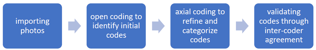
MAXQDA coding procedures.
2.5. Study Design and Variables
This observational qualitative study explored flood causes through visual data without experimental interventions. The primary variables were the themes and scribal issues. Sub-themes (e.g., Å, natural factors, unauthorized construction) were derived from the photos, representing the latent content related to flood causation. Validity was ensured using three strategies from Creswell’s checklist (Creswell and Creswell, 2017): (1) triangulation through expert panel validation, (2) researcher consensus via multiple coders, and (3) inter-coder reliability assessment using the Holsti coefficient (0.85, indicating high reliability as values above 0.80 are acceptable). Results were summarized in a thematic map (Fig. 1) and table (Table 1), illustrating the frequency and distribution of themes and sub-themes.
| Theme | Sub-theme | Initial Code |
|---|---|---|
| Human factors | Construction | Construction on the river route |
| Leveling the waterway and reducing soil permeability | ||
| Placing barriers on the river route | ||
| Decreasing the river outlet | ||
| Impact of infrastructure on floods | ||
| Leveling and constructing roads along the river route | ||
| Poor enforcement of construction restrictive laws within the designated riparian zone | ||
| Technical weakness in damaged buildings in terms of poor design and construction | ||
| Not using suitable construction materials that are resistant to water and moisture | ||
| Demolition of the flood wall and the concrete wall of the river | ||
| Not designing the residential buildings for the flood load | ||
| Inaccurate execution of the blockage | ||
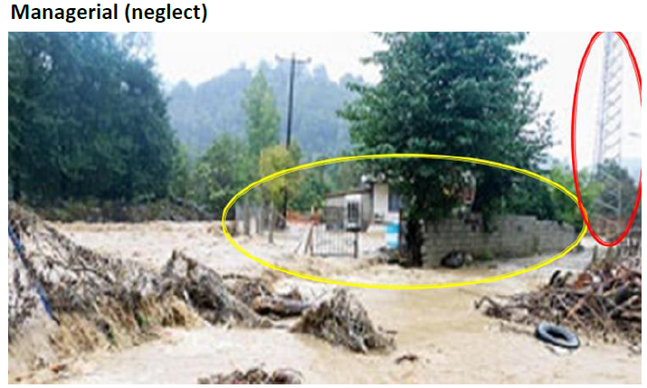
| Managerial (neglect) | Disappearance of the main river route | |
| Reduced the width of the river passage due to the accumulation of wood and other barriers | ||
| Storing timber next to houses and creating a barrier to the passage of water | ||
| Creating a narrow path for the waterway due to the construction of a bridge with narrow span | ||
| Not securing the riverbank to prevent rocks and soil from falling into the river | ||
| Construction of roads on the riverbank | ||
| Construction of railways and roads in the floodplain and prevention of downstream flooding | ||
| Construction of an underpass without considering the drainage system of the water entering the underpass | ||
| The high slope of the underpass and the accumulation of inlet water | ||
| Negligence | People gathering at the site of the incident and an increased risk of collapse of the overpass bridge due to heavy rainfall | |
| Deforestation | Destroying flora along the river route | |
| Natural factors | Heavy rainfall | Surface runoff |
| Geological | Reduced riverbed permeability | |
| Morphological features | Land slope | |
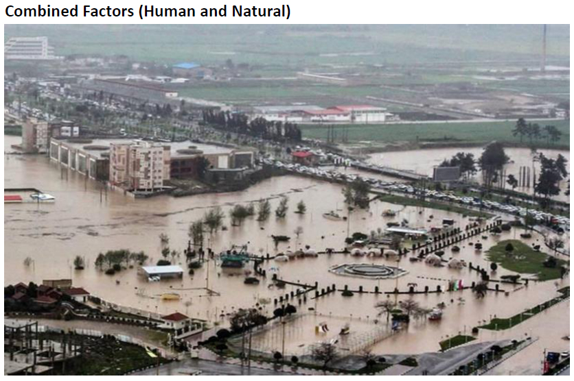
| Combined factors (human and natural) | Soil erosion - managerial neglect | Soil erosion due to frequent droughts and not foreseeing the steep slope overlooking the river passage |
| Loss of vegetation and managerial neglect | Land use change (changing flood plains into agricultural lands and heavy seasonal rainfall) | |
| Watershed management problems | Watershed management problems and the ensuing necessity of targeted riverbed dredging |
3. RESULTS
The experts included 7 men (78%) with a mean age of 48 years, and two women (22%) with a mean age of 35 years. Directed content analysis was used to analyze the data. The direct qualitative content analysis approach comprises three main stages: preparation, organization, and reporting (Elo and Kyngäs, 2008). During the preparation stage, the analysis unit (as shown in a photo in our study) was selected. In the next stage (analysis), the researchers interpreted the data, considered “what was going on,” and gained a sense of the whole. In the organization stage, a data classification and coding matrix was developed. In the reporting stage, the researchers linked the results to the data. The researchers describe the analysis process in as much detail as possible in the appendices and tables. Twenty-nine initial codes were extracted based on open coding, classified into 6 sub-themes and two themes based on the axial coding. After reviewing the codes and interpreting the themes in the expert panel, four sub-themes and a theme were added, and finally, 29 initial codes, 10 sub-themes, and 3 themes were obtained (Table 1).
Examples of the figures are presented below, including the following:
Figures 2 to 16 are related to the theme of human factors (Figs. 2 to 8) are related to construction, Figs. (9 to 12) are related to managerial factors, and Figs. (13 to 16) are related to negligence). Figures 17 and 18 are related to natural factors, and Figs. (19, 20, and 21) are related to the theme of combined factors.
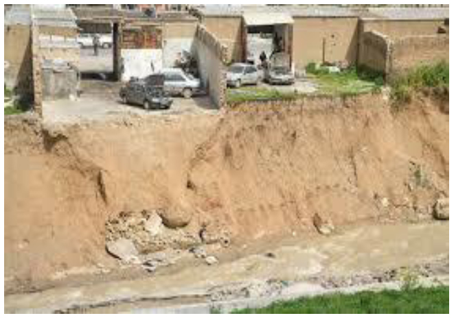
Construction on the river route.
Construction on the waterway and reducing the route.
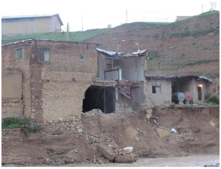
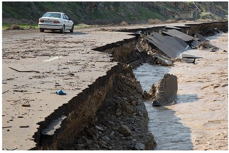
Residential buildings lacking design considerations for flood load and proper technical specifications are more vulnerable along the flood route.
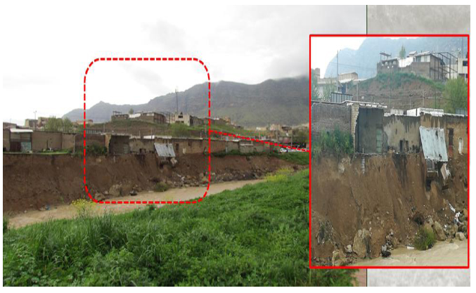
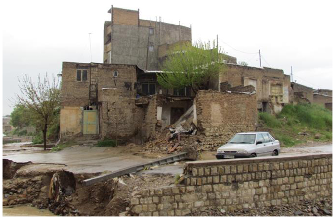
Residential construction along the river upstream route, which has scoured the foundation and destroyed the buildings during the flood.
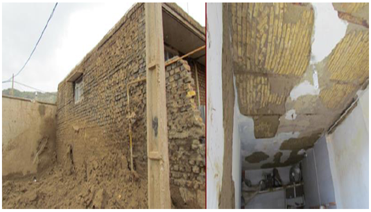
The building with a load-bearing wall system supported by a steel coil and a rough brick arch roof; the adjacent building, which lacked a suitable structural system, was destroyed.
Foundation scouring and collapse of the load-bearing walls and roof.
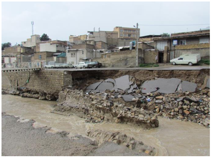
Demolition of the retaining wall and the river by-pass.
Reduced width of the river passage due to the accumulation of wood and other barriers.
Construction of roads on the riverbank.
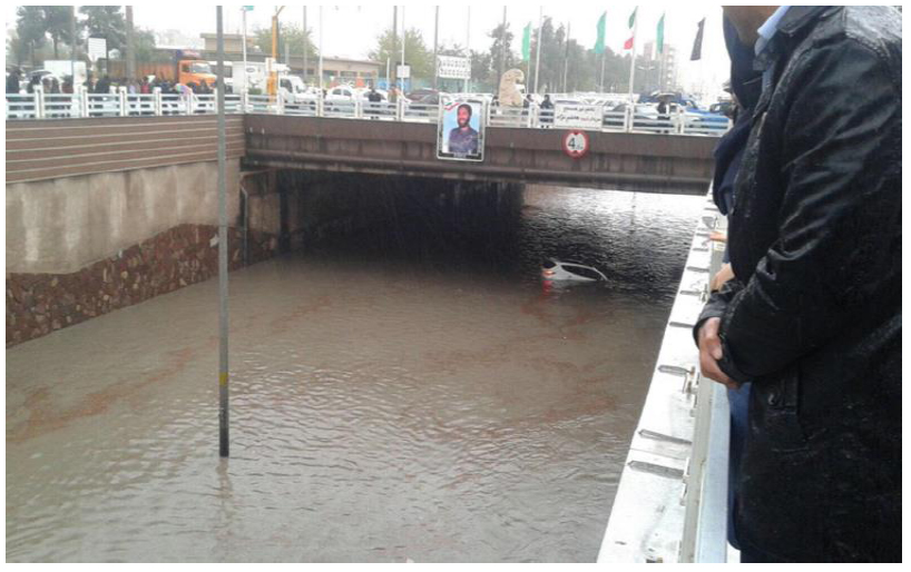
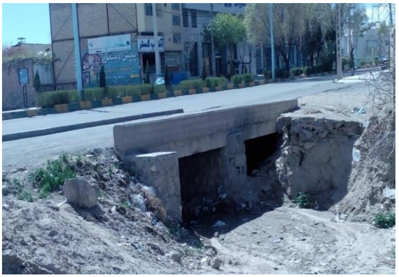
Construction of an underpass without considering the drainage system of the water entering the underpass, the steep slope of the underpass, and the accumulation of inlet water.
A narrow path being created for the waterway due to the construction of a bridge and its narrow span.

Excessive settlement of the kitchen floor due to the use of soil instead of rubble (blockage).
Bridge openings are blocked.
Creating a narrow path for the waterway due to the construction of a bridge and its narrow span.
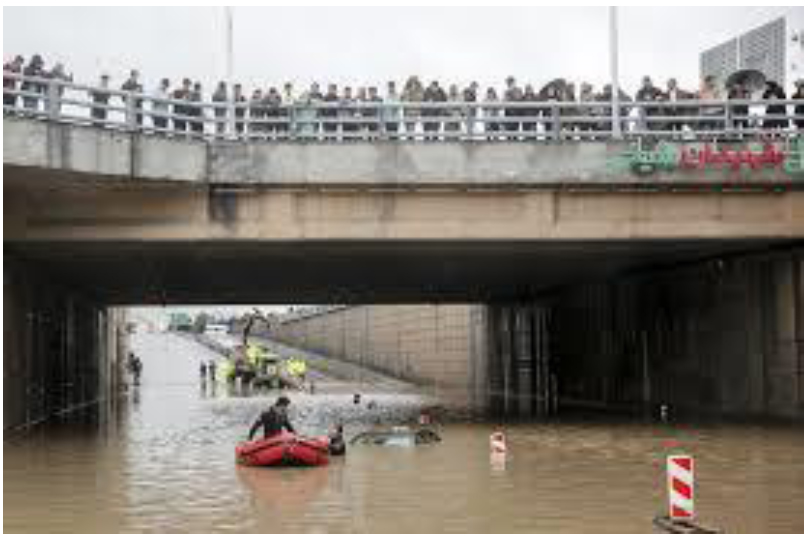
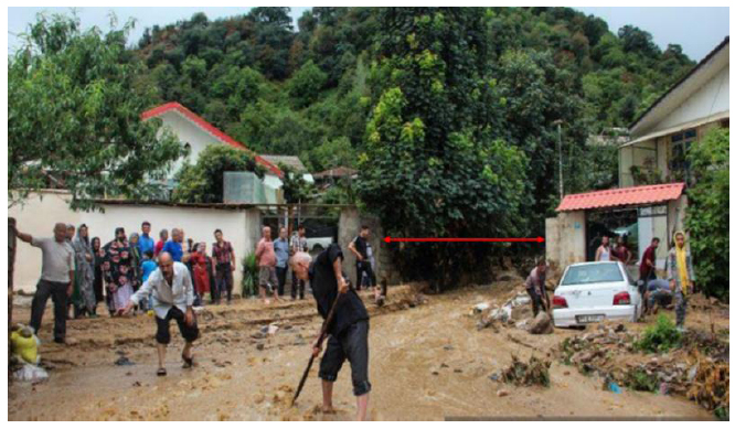
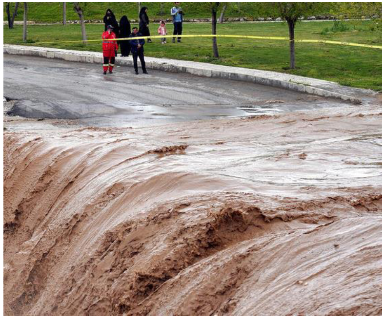
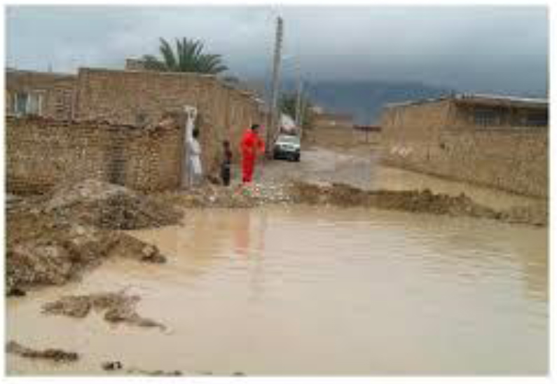
People gathering at the site of the incident, increasing the risk of collapse of the overpass bridge due to heavy rainfall.
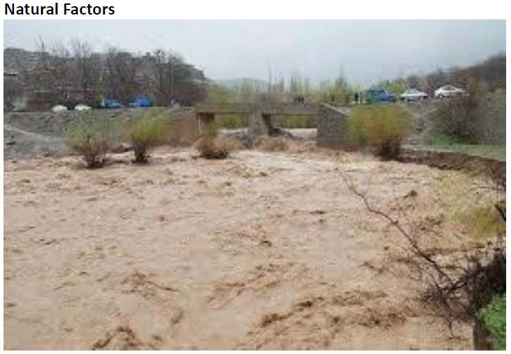
Surface runoff due to heavy rainfall in the southeast of Iran.
Surface runoff caused by a gentle slope of the land.
Inadequate urban structure in directing surface water.
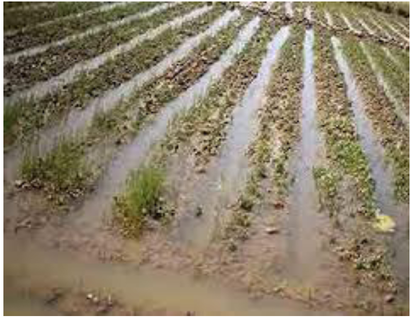
Land use change (changing flood plains into agricultural lands and heavy seasonal rainfall).
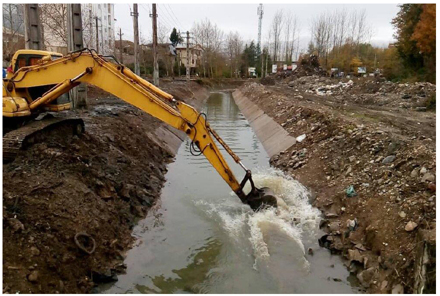
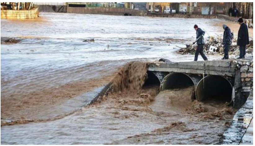
Necessity of targeted riverbed dredging.
5. DISCUSSION
Due to its climatic, topographic, and geomorphological conditions in many regions, Iran is at risk of flooding every year. More than 80% of Iranian cities are at risk of flooding. Since 20 March 2019, a set of floods with severe losses and casualties has commenced in Iran. It first afflicted several cities in the northern provinces, and two days later, it occurred in Shiraz (Fars Province). Later, floods occurred in Lorestan, Khuzestan, Ilam, Kermanshah, Arak, and Hormozgan as well. Rainfall across Iran was so severe that 20 of the 31 provinces are currently at risk of flooding. Based on rainfall statistics, the 2018-2019 water year was one of the most arid years in the past decades. The volume and intensity of rainfall this year show significant differences between last year’s drought and wet periods and the current year (Vaghefi et al., 2019b, Peyravi et al., 2019, Yari et al., 2022, Rautela, P. et al., 2022).
In the present study, according to the analysis of photo and video reports of recent floods in Iran, three themes were obtained regarding the causes of floods in these areas: natural factors, human factors, and a combination of these two factors. The sub-themes included unauthorized construction, managerial factors (inattention), negligence, deforestation, heavy rainfall, geological factors, land morphological features, soil erosion, vegetation loss, and watershed management problems.
One of the sub-themes identified in the present study was unauthorized and non-technical constructions in the riparian zone and canals, and structural alterations in the riverbed, including leveling or demolition of flood walls, and concrete walls protecting the river. Urban and residential development along river banks and the conversion of agricultural land to residential land make the hydrological behavior of urban drainage basins abnormal and irregular compared to that of natural basins. Land use changes alter different components of the hydrological cycle, resulting in an increase/decrease in the volume of runoff. Human activities such as the extraction of gravel and sand, constructing buildings and walls on river banks, artificial building reservoir dams, and changing agricultural land use alter the geomorphological dynamics of the rivers (Yao et al., 2013), thereby directly or indirectly affecting them. Based on the analysis of the photos to discover the causes of floods in the southern and western regions of the country, we found technical weaknesses in damaged buildings in terms of design and execution; for example, using load-bearing wall buildings without coils or without framework, and using poor-quality materials, weakens vulnerable buildings and causes their partial or total destruction.
Inaccurate execution of blockages is another cause deduced from analyzing the photos taken during the flood in different parts of the country. For example, instead of using suitable materials (blockage or using rubble and gravel), local or depot soil has been used, which has caused settlement or subsidence due to a lack of soil compaction and moisture. The findings of this study on the inaccurate constructions that create many barriers to flood passage are in line with the findings of Peyravi et al. (2019), Yang et al. (2021b), Ulbrich et al (2003), and Rajabizadeh et al. (2019b).
One of the important factors intensifying the destructive power of recent floods in Iran was the lack of attention to geographical and environmental characteristics and the prioritization of economic parameters, such as electricity generation in dam construction. In the past two decades, the excessive growth in dam construction in different parts of the country, regardless of soil type, biodiversity, and demographic diversity of the areas and the conditions of the rivers on which the dams were built, fundamentally altered the climatic and geographical conditions of the areas downstream of the dams. In many of the country's water basins, which were affected by driftage instability of surface and subsurface resources, dam construction dried out agricultural lands and aquifers in downstream areas, which had numerous economic-demographic consequences for different regions, especially the Eastern and Central regions (Ahmadzadeh and Saeed Abadi, 2015, Rajabizadeh et al., 2019a).
The most important reasons mentioned by experts for the destructive effects of the dams are: Alteration of soil texture and geometry of rivers downstream of dams, which drastically reduced the width of rivers and caused the accumulation of mud in rivers, the extinction of species such as rare species of fish in rivers, and severe soil erosion downstream of dams (Yari et al., 2020). The theme extracted on dam construction on riverways and reducing river outputs is consistent with the findings of Toorani et al. (2021b), Guangming et al. (2021), and Rezaee Moghaddam et al. (2020).
Other important factors that predispose to and strengthen the destructive power of recent floods are managerial issues and neglect in reducing river flow and in creating barriers along the path of floods. The impact of infrastructure on floods is one of the factors that can cause severe flooding in different areas; for example, a factor that, as a new experience, exacerbated water accumulation in the Golestan flood was the construction of a road and railway on lowlands, especially in the Agh Ghala region. In fact, water was trapped between the road and railway lines, which had a higher height than the ground; not building a culvert to direct the water in the correct direction of the slope and in suitable positions caused the operation of parts of the road and railway axis, such as dams and, thus, water accumulation (Rajabizadeh et al., 2019a).
Another factor increasing the destructive power of recent floods was the lack of dredging of the rivers. It is important to note that dredging rivers increases the flow capacity of waterways and thus reduces the volume of floods. Moreover, 200 km of rivers in the flooded areas in population centers required walling. These defects increased the risk of flooding. The findings of the present study regarding managerial issues and neglecting the standardization of rivers and canals are in line with the findings of Rajabizadeh et al. (2019a) and Khalaj et al. (2021a).
Based on the findings of the present study and the analysis of photos of floods in different parts of the country, people’s negligence and their presence and aggregation at the flood site (increased risk of collapse of the bridge overlooking the flood passage and water accumulation), especially in urban floods, can be life-threatening for citizens. Therefore, increasing the awareness of the hazards and public awareness of how to stay away from the flood can reduce the number of deaths after the flood, according to the findings of the study by Khalaj et al. (2021a).
The analysis of photos of flooded areas showed that deforestation and loss of vegetation are among the causes of floods, and increase the rate of destruction and deaths due to recent floods. It is noteworthy that vegetation plays an important role in delaying the time of flood accumulation, increasing the concentration time, and reducing flood runoff; for example, currently, about 20% of the area of Golestan Province is forest. The degradation of forest and pasture vegetation in Golestan province has the highest rate compared to Mazandaran and Gilan provinces (0.73% per annum), such that from 2004 to 2016, 33,000 ha of forests in this province have been destroyed. The intensification of floods in 2019 due to deforestation was evident. Findings by Toorani et al. (2021b) and Fernando et al. (2022a) also confirm these findings.
Heavy seasonal rainfall was another sub-theme that was identified in the present study based on the analysis of photographs of floods. One of the causes of the devastation of recent floods was heavy rainfall, the capacity of dams being filled before the onset of rainfall, and the lack of dredging of the flowing rivers. The severe drought of the previous water years and the excessive emptiness of dam reservoirs led to the improper conditions of the dams, which expresses the lack of proper management of dam reservoirs before floods. Besides, the significant effect of the inlet water from intermediate basins, the topography of the region, and poor structural and non-structural measures for flood control were the other causes of floods (Fazel-Rastgar, 2020).
Researches show that climate change and global warming exacerbate extreme climatic events (e.g., droughts and floods). Recent excessive rainfalls in Iran after several years of drought remarkably increased the mean rainfall. Another point is the relationship between recent rainfall, floods, and climate change. One cannot know for sure whether the main cause of recent rainfalls is climate change and global warming, or whether rainfall is part of the natural climatic fluctuations. Based on the studies by the reputable Nature journal in 2018, more research is required to discover the effect of climate change on extreme climatic events. Based on studies on 190 extreme climatic events including heat wave, drought, flood, oceanic temperature change, thawing of ice, blizzards, and storms in different regions of the world, two-thirds of these phenomena were originated in or, at least, exacerbated by human activities on the climate (ASSESSMENT, 2021, Fatemi and Moslehi, 2022, de Brito et al., 2022).
Global meteorological models predict a rise in the severity of drought in some regions. Therefore, given the uncertainty in these models' results, a direct relationship between climate change and recent floods in Iran cannot be determined with certainty, and more attention should be paid to human-related and terrestrial factors that exacerbate floods.
One of the themes extracted from the factors causing floods, based on analysis of photographs of the flooded areas, was the morphological characteristics of the land. In this category, the slope of the land was one of the factors that caused or exacerbated floods. Due to the excessive slope of the land around the river, the produced runoff is directed to the population centers rapidly and is then easily distributed due to the flatness of the areas and their low height. The findings of two studies by Shokrian et al. (2020) also confirm the findings of this study.
Watershed management operations are scientific methods for alleviating the effects of floods and their solid load. According to the report on floods in 2019 in Iran, 75 million m3 of the volume of flood water in 2019 was managed behind dams and in watershed management projects, which is < 25% of the flood volume. This percentage indicates that if watershed management programs are implemented, a significant volume of floods can be contained and managed. Other effects of watershed management programs at the implemented points were reducing the flow velocity, increasing water retention, increasing the concentration time, delaying the flood flow, and finally, reducing the flood peak. The findings of this study are consistent with the results of the study of Rajabizadeh et al. (2019a) and Yari et al. (2020).
6. LIMITATIONS
Limitations include: (1) potential selection bias, as participants with access to cameras or smartphones were more likely to contribute photos, possibly under representing certain demographics; (2) subjectivity in coding, as photo interpretation is inherently subjective, though mitigated by expert panel validation; (3) limited generalizability, as findings are specific to Iran’s 2019 floods.
CONCLUSION
The novelty of our study lies in utilizing auto-photography as a participatory, community-driven method to investigate flood causes, a technique that is relatively underexplored in disaster research within Iran. This approach leverages visual documentation by community members to reveal underlying causes of issues and can foster community engagement and empowerment in disaster reduction strategies.
This study utilized auto-photography, a participatory, community-driven method, to investigate the causes of the 2019 floods in Iran, revealing key insights into the interplay of natural and human factors. Analysis of 150 participant-generated photos from 20 flood-affected provinces identified three main themes: natural factors (e.g., heavy rainfall, geological factors, morphological features), human factors (e.g., unauthorized construction, managerial neglect, deforestation), and their combination, which exacerbated flood impacts. These findings highlight the critical role of human activities, such as non-technical construction in riparian zones and inadequate watershed management, in amplifying flood severity, alongside natural contributors like intense rainfall and land morphology.
The results suggest that a comprehensive flood management system, tailored to Iran’s unique climatic, topographic, and social context, could mitigate future flood-related losses. Such a system should prioritize coordinated policies to address unauthorized construction, improve river dredging, and enhance watershed management practices, as evidenced by the identified sub-themes. The novel use of auto-photography underscores its potential to engage communities in disaster research, fostering local awareness and empowerment. By integrating structural and non-structural measures with community input, Iran can develop targeted flood control strategies to reduce the devastating impacts of future floods.
AUTHORS’ CONTRIBUTIONS
The authors confirm their contribution to the paper as follows: H.A.: Study conception and design; M.A.M.: Data collection; M.N.: Data curation; M.R.: Draft manuscript. All authors reviewed the results and approved the final version of the manuscript.
ETHICS APPROVAL AND CONSENT TO PARTICIPATE
Ethical approval was obtained from the Vice Chancellor for Research of Kerman University of Medical Sciences (IR.KMU.REC.1401.073) prior to data collection.
HUMAN AND ANIMAL RIGHTS
All procedures performed in studies involving human participants were in accordance with the ethical standards of institutional and/or research committee and with the 1975 Declaration of Helsinki, as revised in 2013.
AVAILABILITY OF DATA AND MATERIALS
All data generated or analyzed during this study are included in this published article.
FUNDING
The Kerman University of Medical Sciences supported all sources of funding for this research.
ACKNOWLEDGEMENTS
The authors would like to thank the Kerman Governor's Crisis Management Headquarters for cooperating with this project.

